
Dramatic dinosaur footprints at Karoola station, Australia
Fleeing the rising waters of Noah’s Flood

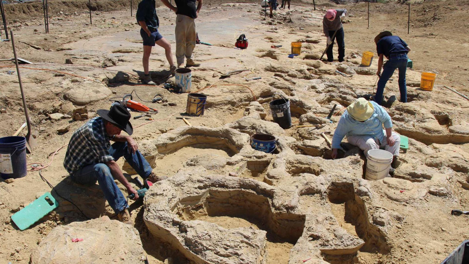
In September 2018, a 20-strong team of palaeontologists and volunteers gathered near Karoola homestead in Central West Queensland to rescue a slew of dinosaur footprints (figure 1).1,2,3 Over 20 days, they excavated endangered tracks from a dry creek bed and moved them some 100 km to the Australian Age of Dinosaurs Museum near Winton, founded by Executive Chairman, David Elliott. Australian vertebrate palaeontologist Dr Stephen Poropat of Swinburne University of Technology in Melbourne is leading the research work.
The tracks were first exposed 20 years before when floods altered the course of the creek. Although landowners often passed the impressions, they did not recognise their significance (figure 2). However, a couple of years ago, a visitor suggested the features were dinosaur footprints, an opinion later supported by palaeontologists.
Some 25 per cent of the total footprint area, which was about the size of two basketball courts, was relocated, including all the fragile prints. Relocation will continue to the end of winter 2019.

Significance of the tracks
These tracks vividly reveal the drama of Noah’s Flood as it deluged the earth. We catch a glimpse of how animals reacted, leaving footprints as they fled the floodwaters rising on what is now Australia. Before these prints were made, kilometres of sediment had already been deposited on the continent, burying terrestrial and marine creatures. More sediment was deposited afterwards.
Tracks of three major dinosaur groups were preserved—sauropods, ornithopods and theropods. A string of 20 prints from a large sauropod dinosaur extends for 40 metres. The hind footprints were nearly a metre across. They were well-preserved, including the impression of the thumb claw on most fore prints and the marks of individual toes. The stress of the sauropod’s step left mud cracks in the moist sediment around many of its footprints. The prints in the sandstone are so big that people could comfortably sit in them (figure 3). Obviously, the dinosaur had walked on the sand layer soon after it was deposited while it was still soft and wet. It all happened quickly.
Other dinosaurs left footprints too, including small ornithopods and chicken-sized theropods. In addition, tracks of other sauropod dinosaurs were present, including at least one sub-adult, but they had been trampled by other animals.
The ornithopod and theropod footprints were like those preserved at Dinosaur Stampede National Monument, at Lark Quarry some 100 km south of this site.4 At Lark Quarry the dinosaurs were shoulder deep in water, suggesting they were trying to escape being inundated. This indicates that the Flood not only engulfed many animals but covered a huge geographical area.

The extent of catastrophe
The dinosaur footprints are found in the uppermost sediments comprising the Great Artesian Basin, which even today still cover a large proportion of Eastern Australia (figures 4 and 5). Conventional geologists have assigned these deposits to the period from the Late Triassic to the Late Cretaceous (210 to 94 million years ago in their evolutionary thinking). These dates assume that Noah’s Flood never happened, and that all sediments were deposited slowly over millions of years, contradicting the obvious evidence for catastrophe.
The date assigned to the Karoola prints is 95 million years, but the geologic evidence and the biblical account indicate these sediments were deposited catastrophically, which did not take that much time. The evidence indicates they were the last major deposit as the floodwaters were rising during Noah’s Flood, which took place about 4,500 years ago (see Great Artesian Basin).5 More specifically, they would have been deposited around the fifth month of the year-long Flood (Genesis 8:3–5). After that, the floodwaters began to recede into the oceans.

The uppermost sediments, called the Winton formation, are exposed over large portions of remote Central West Queensland, in addition to northern New South Wales, north-western South Australia and the south-western corner of the Northern Territory.6,7 The formation is composed of easily-broken sandstone, siltstone, mudstone, and minor coal. The average thickness of the formation is 500 metres, but it reaches a maximum of 1,200 metres.8 It contains abundant fossils of freshwater bivalves, sauropod dinosaurs, plants, wood, spores, and pollen.6 The size and extent of the formation together with its fossils provide an insight into the huge catastrophe that uprooted the pre-Flood vegetation, overwhelmed animals, and impacted the continent.
Rising floodwaters, erosion, and time
After the waters of Noah’s Flood reached their peak, they began to flow off the continent into the oceans. This process took some seven months, eroded kilometres of sediment from the continent, and formed the distinctive shape of the present landscape.5 We can see this evidence in the Winton area in the flat landscape, which was formed by the floodwaters when they covered the whole continent. We can also see other distinctive features of the receding floodwaters in the area in the wide river valleys that have dissected the land surface, leaving distinctive mesas and plateaus, which are locally called breakaways or jump-ups (figure 6).

The layer of sandstone was exceptionally soft when the animals walked on it, as we can see from the shape of the footprints (figure 3). The steps of the large sauropod made prints many inches deep with edges that stand up vertically. The softness of the sediment layer means that the whole deposit was deposited quickly, and the dinosaurs walked on the sandstone layer not long after. Moreover, the overlying layer of sediment needed to have been deposited on top of the prints very quickly afterwards, or the prints would have weathered away or been destroyed by other animals walking on them. All this evidence is consistent with the timeframe of Noah’s Flood.
The Bible tells us that everything that had the breath of life in it perished once the waters of Noah’s Flood reached their peak (Genesis 7:21–23). To make tracks the dinosaurs were still alive, which means the floodwaters were still rising and had not yet reached their peak. But it was not long after they made these tracks that the animals were overwhelmed by the rising water. The fossil remains of many of these animals have been found buried in the area.
Conclusion
The remarkable dinosaur footprints discovered at Karoola Station in outback Queensland, Australia, provide dramatic evidence of the reality of Noah’s Flood. Further, they provide insight into the nature of the catastrophe and its effect on the animal life at the time. Understanding the effects of Noah’s Flood changes the way we look at the world and how we understand our place in it.
References and notes
- Smith, B., Tracks across time: The race to rescue 95-million-year-old dinosaur footprints from the elements in the Queensland outback, ABC Science, https://www.abc.net.au/news/2019-02-14/the-race-to-save-wintons-dinosaur-footprints/10578212. Return to text.
- Giant dinosaur tracks discovery focuses global attention on Winton, Minister for Innovation and Tourism Industry Development and Minister for the Commonwealth Games, The Honourable Kate Jones, Queensland Government, 14 February 2019; http://statements.qld.gov.au/Statement/2019/2/14/giant-dinosaur-tracks-discovery-focuses-global-attention-on-winton. Return to text.
- Sauropod trackway, Australian Age of Dinosaurs Museum. http://www.australianageofdinosaurs.com/page/119/australian-age-of-dinosaurs-sauropod-trackway, Accessed 30 April 2019. Return to text.
- Michael J. Oard, A stampede of swimming dinosaurs, Creation 36(1):38–41, 2014; https://creation.com/dino-stampede Return to text.
- Walker, T., The Great Artesian Basin, Australia, Journal of Creation 10(3):379–390, 1996; https://creation.com/great-artesian-basin Return to text.
- Day, R.W., Whitaker, W.G., Murray, C.G., Wilson, I.H. and Grimes, K.D., Queensland Geology: A Companion Volume to the 1:2,500,000 Scale Geological Map (1975), Geological Survey of Queensland, Publication 383, Brisbane, p. 138, 1983. Return to text.
- Fletcher, T.L, Moss, P.T., and Salisbury, S.W., The palaeoenvironment of the Upper Cretaceous (Cenomanian–Turonian) portion of the Winton Formation, Queensland, Australia, PeerJ 6:e5513, https://doi.org/10.7717/peerj.5513. Return to text.
- Winton Formation, Australian Stratigraphic Units Database, Geoscience Australia; https://asud.ga.gov.au/search-stratigraphic-units/results/20268, Accessed 1 May 2019. Return to text.


Readers’ comments
Comments are automatically closed 14 days after publication.