

Journal of Creation 29(1):103–107, April 2015
Browse our latest digital issue Subscribe
The Sedimentary Heavitree Quartzite, Central Australia, was deposited early in Noah’s Flood
A detailed study of the sedimentary structure and geographical extent of a prominent and widespread sandstone unit in central Australia reveals evidence of high energy depositional processes. The sheet-like nature of the Heavitree Quartzite indicates that an abundant supply of sediment was deposited and distributed in a high-energy, shelf-like environment. The extent of the sedimentary formation indicates that the depositional process represented a cataclysm of continental scale. Abundant sediment supply was transported to the flat, shallow depositional basin by wide flowing rivers. The sediments were laid down rapidly throughout the basin by high-energy water flows associated with the shallow marine environment of the basin, and by rapid changes in relative sea level. In the early stages of deposition strong reversing tidal currents played a major role in dispersal, but as water depths increased unidirectional currents became dominant. These findings from sedimentological analysis are indicative of the types of depositional environments expected during the early phase of Noah’s Flood.
Oxides of iron give central Australia its distinctive reddish hue. Because vegetation is sparse, rocky strata are visible in the cliffs of the MacDonnell Ranges, which run for hundreds of kilometres across the ‘Centre’ (figure 1). These geological features of central Australia reveal compelling evidence of the global Flood catastrophe of Noah’s day.
Internal sandstone structure indicates catastrophic deposition

One impressive feature is a quartz-sandstone formation in the prominent ridges of the MacDonnell Ranges, called the Heavitree Quartzite (figure 2). This formation is composed mostly of quartz sand, with white and tan grains cemented into very hard rock by silica cement.
Where the Heavitree Quartzite is exposed in cliffs and gorges it often shows prominent layers. The strata are usually dipping, having been tilted by tectonic activity. Within each of these strata it is usually possible to see fainter lines running at an angle.1 This ‘cross-bedding’ forms when sand is deposited by flowing water, somewhat similar to the way moving water creates sand ripples on a beach. The ripples move sideways with the water leaving the pattern of crossbedding as the sediment accumulates.

Figure 3 illustrates how cross-beds form, with the water flow carrying the sediment into the area and dropping it onto the front of the sloping sand surface, forming ‘foresets’. The foresets face the direction of the water flow, and from their height and shape the speed and depth of the water may be inferred.
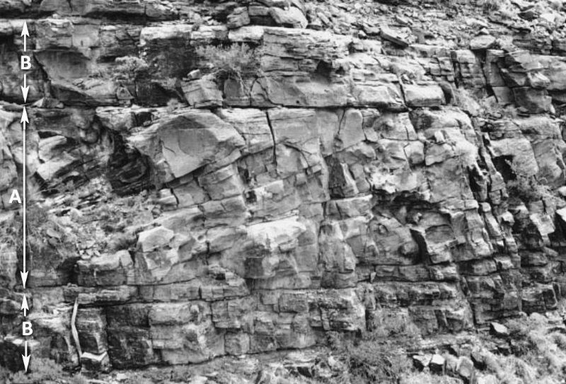
Geologist John Lindsay described the bedding in the lower portion of the Heavitree Quartzite, a portion he calls ‘Sequence 1’.2 In the middle of his photograph2 (Figure 4) the typical large-scale foresets (labelled ‘A’) are visible with the cross-beds dipping downward toward the left, indicating water flow from the right. The cross-beds are of sigmoidal shape (i.e. slightly curved like an ‘S’) but the top part of the sigmoidal cross-beds has been cut off by a thinner bed of flat-lying sandstone (labelled ‘B’). There is a similar thinner bed beneath the cross-beds (also labelled ‘B’).

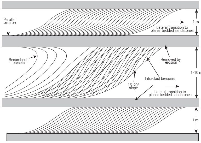
Lindsay also published a diagram to illustrate the internal features of the quartzite beds (figure 5). It shows three beds with the typical sigmoidal foresets, with the top and bottom examples being 1 m thick. This thickness points to a significant depth of flowing water carrying abundant sand into the area and depositing it. Lindsay describes the flow direction as unidirectional and well defined.2
On the middle bed of his diagram (Figure 5) Lindsay indicates that beds can be up to 10 m thick. Typically, when cross-beds become larger than a metre or two mainstream geologists have difficulty interpreting how the sediments were deposited. The reason is philosophical. With a uniformitarian bias, they aim to explain past geology in terms of a modern environment. However, enormous water flows depositing huge volumes of sand over large areas are not observed today. Consequently, mainstream geologists speak of “the uncertainty about the details of their depositional setting”, or that the setting is “not well understood”.2
One of the standard responses is to interpret cross-bedded deposits as wind-blown (aeolian) because large sand dunes are observed to form in desert environments today. However, these foreset beds are truncated by thin flat beds, and they also grade laterally into plane-bedded sandstones (Figure 5).
The internal shape of a sedimentary bed depends on a number of factors such as grain size and flow velocity. As the flow velocity increases, the beds change from angular cross-beds to flat-beds, a bedform described as ‘upper flat-beds’, where ‘upper’ refers to high velocity. Figure 5 shows that the top of the middle cross-bed is truncated by a flatbed, indicating that both bedforms were deposited by water, and that the flow was strong. This means that there was a significant depth of fast-flowing water depositing these beds.
Figure 5 illustrates another feature of the sandstone deposits. The middle row of foresets, toward the left-hand side, shows the sigmoidal shape changing into ‘recumbent foresets’. This indicates that the water flow (coming from the right to the left) was so strong that the sand dunes were ‘bent’ backwards by an “intense shear stress generated by the high velocity currents”.2
From his observation and analysis of the sedimentary structures of the sandstone, Lindsay2 concluded that the Heavitree Quartzite formed from wide flowing rivers delivering an abundant supply of sediment into a huge, flat, shallow depositional basin. The basin was subsiding relative to the water level, and the sediment delivered was readily dispersed throughout the basin because of the high-energy water currents associated with the shallow marine environment of the basin and by major changes in relative sea level. In the early stages of deposition strong reversing tidal currents played a major role in dispersal, but as water depths increased, unidirectional currents became dominant. Lindsay’s description graphically pictures the sort of environment that we would anticipate early in the Noahic Flood. With this magnitude of energy involved in the delivery and dispersal of the sediments, we would also expect the flows of water to impact a large geographical extent, and this is what geologists have discovered.
Huge geographical extent

The Heavitree Quartzite covers a large area, being the basal deposit within the Amadeus Basin, which lies in the middle of the Australian continental block; a basin that is 850 km long from east to west, and 250 km wide (Figure 6). The Heavitree Quartzite covers an area2 of some 158,000 km2.
Figure 7 shows a geological cross-section of part of the Amadeus Basin from north to south. The Heavitree Quartzite is the earliest sedimentary formation deposited in the basin, being the basal unit deposited over the unassigned crystalline basement. Uplift has exposed the quartzite formation in extensive outcrops along the north side of the Amadeus Basin, where it forms prominent ridges in the MacDonnell Ranges. Outcrops are almost continuous across the basin, from west to east—i.e. from the Western Australian border to the Simpson Desert.
Even though the Heavitree Quartzite is 1,000 m thick, its large geographical extent means that it has an “unusually thin sheetlike geometry”.2 This is a mystery for the geologist who seeks to explain past geological features by processes that are observable today. In modern environments sediments are not seen to be deposited with this geometry. Shallow marine currents do not have sufficient energy to disperse such a huge volume of sediment so rapidly over such a large area.2 However, this sort of geometry is consistent with high-energy deposition, and this is what is expected in the global cataclysm of Noah’s Flood.3
Return to text
The Centralian Superbasin

Not only is the thick, geographically extensive quartzose sandstone prominent in the Amadeus Basin, but the same type of sandstone units are present in neighbouring sedimentary basins of a corresponding geologic ‘age’. This indicates that the geographical extent of the watery catastrophe reached far beyond the Amadeus Basin.
Figure 8 shows the location of sedimentary basins outcropping in central Australia with similar assigned ages. These are the Amadeus Basin, Officer Basin, Ngalia Basin, Wolfe Basin, Georgina Basin, and the Adelaide Geosyncline. The Warburton Basin is a subsurface basin also considered to be of the same age.
The sedimentary unit at the base of each of these basins is a thick, laterally persistent quartzose sandstone with a sheetlike geometry.4 Stratigraphic equivalents to the Heavitree Quartzite have been given different names in different basins, and occasionally in different parts of the same basin. Lindsay sets these equivalent names in a table reproduced as Figure 9, and indicates the geographical extent of this unit on the map, shown in figure 10. The broad geographical extent of these sedimentary units has led some geologists to refer to this region as the Centralian Superbasin,2 a basin that encompasses all the basins of the region. Geologists have suggested that these sandstone units were related to basin dynamics, being the first units deposited following widespread basin subsidence.

Timing within biblical history
The characteristics of the aforementioned quartzose sandstone units are different from what would be expected if the quartzites were deposited by processes similar to what is observable today. Stratigrapher Andrew Miall reaches the same conclusion:
“We need a new approach to uniformitarianism, because of the disconnect … between those working on the modern and the ancient record. It could be argued that the analog method on which modern sedimentology is based, is no longer a satisfactory foundation for research into long-term geological processes.”4

The problem for modern sedimentologists is that they ignore the most important factor in the formation of the ancient record, namely Noah’s Flood. The Heavitree Quartzite is consistent with that event.
Some biblical geologists suggest that Neoproterozoic deposits such as these represent the very first deposits of the Flood, forming as a result of the breakup of the fountains of the great deep (Genesis 7:11).5 The Heavitree formation may have formed as great rainfall early in Noah’s Flood caused immense erosion of pre-Flood continents.
Others have proposed that the pre-Flood boundary is geologically much lower, even at the base of the transition zone in the earth’s mantle.6 With a lower boundary, the crystalline basement on which the Heavitree Quartzite is deposited, as shown in the geological cross-section (figure 7), would have formed earlier in the Flood, and its erosion provided the material comprising the Heavitree Quartzite. One argument for a lower boundary relates to the massive igneous activity associated with deposits earlier than Neoproterozoic, such as granitic plutons, basaltic intrusions, high-temperature komatiites, and enormous igneous dykes. According to the historical record in Genesis, six times during Creation Week, the creation was described as ‘good’ (Genesis 1:4, 10, 12, 18, 21, 25). At the end of the sixth day, when creation was finished, God described the whole of creation as ‘very good’ (v. 31). Hot lavas, voluminous and cataclysmic, releasing ash and noxious gases into the atmosphere do not give the impression of being ‘very good’, and consequently should not be assigned to Creation Week. In this view it would be more likely that they erupted early during the Flood.7 A lower pre-Flood boundary would mean that although the Heavitree Quartzite would have been deposited early in the Flood it would not have been at the very beginning of the Eruptive phase.8
Either way, the Flood provides the key.
Conclusion
The Heavitree Quartzite and its thick stratigraphic equivalents in neighbouring sedimentary basins provide powerful evidence of high-energy watery environments that rapidly deposited abundant quartzose sediment over a widespread area of what is now central Australia. This occurred prior to the deposition of the fossil-bearing sediments of the Phanerozoic. The characteristics of the deposit reflect processes having far greater energy than the sorts of processes observable today, which is inconsistent with the principle of uniformitarianism. However, the characteristics of the deposit are consistent with what is expected from Noah’s Flood, with the deposits forming early during that global event.
References and notes
- In the Heavitree Quartzite the cross-bedding is often masked by a silica mineral that has cemented the grains of sand together. Return to text.
- Lindsay, J.F., Heavitree Quartzite, a Neoproterozoic (Ca 800–760 Ma), high-energy, tidally influenced, ramp association, Amadeus Basin, central Australia, Australian J. Earth Sciences 46(1):127–139, 1999 | doi: 10.1046/j.1440-0952.1999.00693.x. Return to text.
- Walker, T., Sedimentary blankets: Visual evidence for vast continental flooding, Creation 32(4):50–51, 2010; creation.com/blankets. Return to text.
- Miall, A., Fluvial Depositional Systems, Springer Geology, Springer International Publishing, Switzerland, 2014 | doi: 10.1007/978-3-319-00666-6_1. Return to text.
- Dickens, H. and Snelling, A.A., Precambrian geology and the Bible: a harmony, J. Creation 22(1):65–72, 2008. Return to text.
- Hunter, M.J., The pre-Flood/Flood boundary at the base of the earth’s transition zone, J. Creation 14(1):60–74, 2000; creation.com/pre-flood-boundary. Return to text.
- Volcanoes during Creation Week, Letters to the editor by Esperante, R. and Walker, T., J. Creation 22(1):50–52, 2008. Return to text.
- Walker, T.B., A biblical geologic model; in: Proceedings of the Third International Conference on Creationism, Walsh, R.E. (Ed.), Creation Science Fellowship, Pittsburgh, PA, pp. 581–592, 1994. Return to text.
- Shaw, R.D. and Warren, R.G., Hermannsburg (1:250,000 scale geological map), Australian Geological Survey, Canberra, 1995. Return to text.


Readers’ comments
Comments are automatically closed 14 days after publication.