

The Vredefort Dome, South Africa
Formed by an enormous asteroid impact during a global watery catastrophe

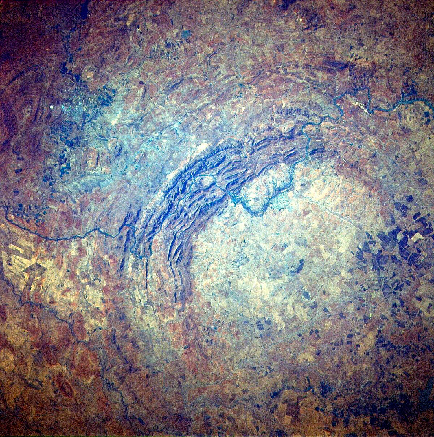
The village of Vredefort (pronounced: free ED duh fort = ‘peace fort’) southwest of Johannesburg in South Africa sits at the middle of what is widely regarded as the largest impact structure on Earth. It nestles in a beautiful farming area with rolling hills, ridges, and valleys. The Vaal River, which marks the boundary between the provinces of North West and Free State, winds across the country and between the surrounding mountains. (figure 1)

A change in perspective
For more than 100 years, the origin of the Vredefort structure has been controversial. Initially it was thought that volcanic magma (melted rock) welling up from beneath the earth’s surface formed the circular feature.1 This explanation was driven by the doctrine that geological features must be explained by the slow processes we observe today operating over enormous expanses of time. It was considered geological heresy to use a process not natural to the globe, or to invoke an extraordinary event. Consequently, well into the mid-20th century, extraterrestrial impacts were considered taboo.2
Despite this, beginning in the first half of the 20th century, some scientists began suggesting that various circular features on Earth, including the Vredefort ‘ring’, looked like they had been formed by asteroid impacts. This idea eventually became widely accepted but controversy continued in South Africa until the mid-1990s.1 Over many years different techniques were used to assemble evidence for an impact origin of Vredefort, including mapping the geology of the area, recording the distribution of metamorphic rocks (rocks that have been changed by heat, for example), and modelling the impact on computers. Eventually people were persuaded, and in 2005, the Vredefort Dome was World Heritage listed as the world’s largest impact structure.3
Evidence for the impact
When you visit the area, the impact structure is not immediately obvious because of its enormous size and erosion. It is only from satellite images (figure 2) and geological maps (figure 3) that the 80-km (50-mile) diameter semi-circular ring of mountains looks like an impact structure. This ring, however, is considered to be just the inner portion of the crater. There is a larger 300-km (200-mile) structure,4 extending to Johannesburg and beyond, and this is even less evident. One complicating factor is that much of the structure has been eroded away.
According to calculations, the asteroid that formed Vredefort would have been around 10 km across,5 making it one of the largest ever to smash into the planet. When it hit, the land surface there was 7–10 km higher. Within seconds, the meteor penetrated kilometres into the earth’s crust, pushing it down. The crust then rebounded, uplifting rocks that had been deep underground, forming a ring of hills, like a collar, around the inner part of the crater—the Vredefort ‘Dome’.6 The ring of hills is composed of metamorphosed layers that now sit almost vertically. They include gold-bearing quartz-conglomerate layers, kilometres thick, which are part of the famous Witwatersrand Supergroup. Some century-old abandoned mine shafts still exist in the ring of hills.
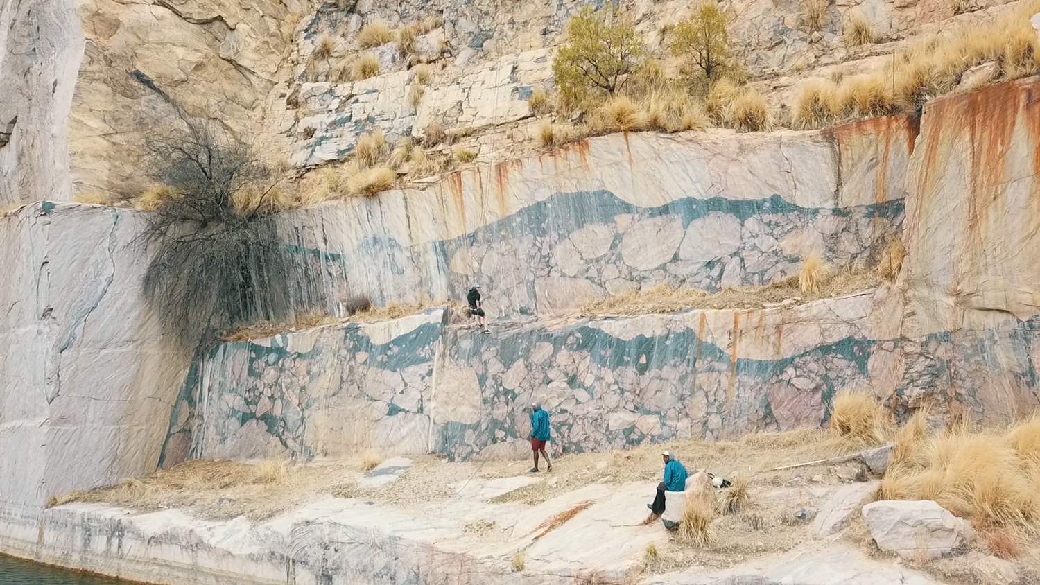
The area inside the ring is granitic rock (figure 3), which forms the basement of the area. Before the granite rebounded, it sat more than 20 km (10 miles) beneath the surface.4 The force of the impact deeply fractured the granite, and partly melted it. Some magma was rich in iron and magnesium and filled the cracks, enveloping chunks (clasts) of broken granite, and solidifying into a black, glassy rock called pseudotachylite (soo DO tacky lite). Because it has been found at a number of impact sites around the world it has been taken as evidence for the asteroid impact. Leeuwkop Quarry near Parys shows magnificent exposures of pseudotachylite enveloping large, rounded chunks of granite (figure 4).


Other magma was rich in silica and aluminium. This flowed into other cracks forming a light coloured rock called granophyre (GRAN oh fire), which is exposed as a number of long dykes in the area (figure 5). These dykes and the pattern they form are also evidence for the impact.7
A common feature in the upturned rocks around the dome is shatter cones—a fracture pattern resembling a fir tree (figure 6). These have been discovered at other impact sites, and are interpreted as being caused by high pressure shockwaves from the impact.
These and other evidences have persuaded people to accept that the structure was formed by an asteroid.
Geological catastrophe
An asteroid impact means that enormous geological changes happened very quickly. We are not talking about a million years, or even one year, or a day. Within a few seconds, a primary crater more than 100 km (60 miles) in diameter and 20 km (12 miles) deep would have been excavated. The crust rebounded after a few more seconds, tipping sediments kilometres thick vertically up and around an uplifted central dome. Then the dome began to collapse, and the whole crater of 300 km (200 miles) would have been completed in 10 minutes or so.8

All this is said to have happened very early in the geological history of South Africa. The primary way the timing is worked out is through geological relationships (figure 3), some of which are visible on the schematic cross section of figure 7. The granitic basement existed first, before a thick sequence of sedimentary and volcanic layers was deposited in a watery environment—the oldest layer at the bottom and the youngest at the top. The asteroid struck the uppermost layer, deformed all the layers and the basement, formed the crater, blasted ejecta (debris) from the crater, and uplifted the central dome.
Long-age geologists have assigned a date of 2,023 million years ago for the impact, based on measurements of isotopes of uranium and lead in some zircon crystals collected from the pseudotachylite and granophyre dykes.9 While the relative ages of the rocks are soundly based on observable field relationships, the claimed ‘absolute’ ages obtained from the isotopic dating methods are not objective. These are based on multiple assumptions, including about the initial concentration of isotopes, and the effects of subsequent geological disturbance on the samples, of which there were many. Unravelling the effect of all these disturbances on the isotope relationships within each zircon is speculative. The different numbers obtained from the different samples are ‘interpreted’ after the event to create a narrative—one that fits the field relationships and the assumed long-age scenario for Earth history.10 Because long-age dates are so subjective, it is possible to develop a different narrative—one that fits a biblical scenario for Earth history.
The asteroid impact would have occurred early in Noah’s Flood.11 We say it was during the Flood and not Creation Week because everything at the beginning was “very good” (Genesis 1:31). An asteroid impact would have filled the atmosphere with deadly ash and dust, which would not have been good. But the impact would not have initiated the Flood because the layers of rock deposited before the impact would also have been deposited early in Noah’s Flood. These include deposits of basaltic lava kilometres thick in a sequence called the Ventersdorp Supergroup.12 Huge outpourings of volcanic lava would have contaminated the atmosphere with toxic fumes, and not been “very good” either. In fact, these outpourings were too large (in thickness and geographical area) to have occurred after the Fall and before the Flood; human life would not have survived such massive volcanic contamination without the relative protection of the waters of the Flood blanketing the eruptions.
After the impact, geological upheavals continued, forming such features as the Bushveld Complex, the Cape Supergroup and the Karoo Supergroup,13 as the waters of the Genesis Flood were rising. In this period rocks were folded and eroded on several occasions.
After the waters eventually covered the whole continent, kilometres of thickness of rock were eroded as they receded, forming the Great African (Planation) Surface,14 and exposing the Dome. With further drops in the water level the reduced flow cut curious drainage patterns around the Dome, including numerous water gaps through the tilted ring of mountains, through which the Vaal River flows today. Slow erosion over millions of years does not explain these patterns, but the receding waters of the Flood do.

Conclusion
The Vredefort impact crater, of which the Vredefort Dome represents the inner portion, formed early in Noah’s Flood. The size of the impact demonstrates the enormous catastrophic forces that shook the earth at that time. The folding and uplift of the sediments produced by the impact took place in a very short period of time—less than a day. As the Flood catastrophe continued, not only did it deposit thick sequences of sediments and volcanic lava on top of the impact crater, but it subsequently eroded them away, exposing the deep impact structure at the surface, along with the uplifted sediments of the famously gold-rich Witwatersrand Supergroup.
References and notes
- Reimold, W.U. and Koeberl, C., Impact structures in Africa: A review, J. Afr. Earth Sci. 93:57–175, 2014, p. 119 | doi:10.1016/j.jafrearsci.2014.01.008; 1464343X1400017X. Return to text.
- Marvin, U.B., Impact and its revolutionary implications for geology; in: Sharpton, V.L. and Ward, P.D., Global Catastrophes in Earth History; An Interdisciplinary Conference on Impacts, Volcanism, and Mass Mortality, Geological Society of America Special Paper, 1990. Return to text.
- Proposal: Vredefort Dome World Heritage Site, Free State Province, Republic of South Africa, Department of Tourism, Environment and Economic Affairs, 2005; unesco.org. Return to text.
- Therriault, A.M., Grieve, R.A.F., and Reimold, W.U., Original size of the Vredefort Structure: Implications for the geological evolution of the Witwatersrand Basin, Meteorit. Planet. Sci. 32:71–77, 1997. Return to text.
- .Reimold and Koeberl, ref. 1, p. 124. This assumes the asteroid impacted a solid earth. Return to text.
- Norman, N. and Whitfield, G., Geological Journeys: A traveller’s guide to South Africa’s rocks and landforms, Struik Nature, Cape Town, pp. 60–61, 2006. Return to text.
- Therriault, A.M., Reimold, W.U., and Reid, A.M., Geochemistry and impact origin of the Vredefort Granophyre, SAJG 100(2): 115–122, 1997. Return to text.
- .Reimold and Koeberl, ref. 1, p. 74. Return to text.
- Reimold and Koeberl, ref. 1, p. 127. Return to text.
- Spray, J.G., Kelley, S.P., and Reimold, W.U., Laser probe argon-40/argon-39 dating of coesite- and stishovite-bearing pseudotachylytes and the age of the Vredefort impact event, Meteoritics 30:335–343, 1995 | doi: 10.1111/j.1945-5100.1995.tb01132.x. Return to text.
- Oard, M.J., Precambrian impacts and the Genesis Flood, J. Creation 28(3):99–105, 2014;creation.com/precambrian-flood. Return to text.
- Reimold and Koeberl, ref. 1, p. 122. Return to text.
- Norman, N. and Whitfield, G., Simplified geology of South Africa, Lesotho and Swaziland; in ref 6 inside front cover. Return to text.
- Oard, M.J., The remarkable African Planation Surface, J. Creation 25(1):111–122, 2011; creation.com/african-planation Return to text.


Readers’ comments
Comments are automatically closed 14 days after publication.