

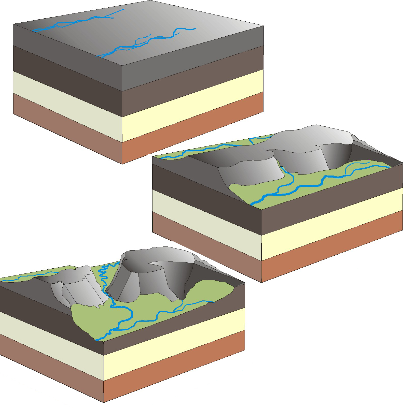
Water and wind gaps carved during channelized Flood runoff

Water and wind gaps, two amazing landforms on the earth’s surface, cut through mountains and ridges.1 They are exciting evidence for the global Flood.2,3 According to the Glossary of Geology, a water gap is defined as: “A deep pass in a mountain ridge, through which a stream flows; esp. a narrow gorge or ravine cut through resistant rocks by an antecedent or superposed stream.”4 In other words, a water gap is a perpendicular cut through a mountain range, ridge, or other rock barrier. It is a gorge that a river or stream flows through. It is highly unlikely these gorges were cut by the river that now runs through. Wind gaps are like water gaps but are not deep enough for water to flow through. Only wind passes through, which is why they are called wind gaps.
‘Loaded’ geological definitions
Geological definitions are supposed to be descriptive, but the above definition of a water gap contains two hypotheses that assume their origin: an antecedent and a superposed stream. The first hypothesis involves an ‘antecedent stream’, which is defined as a stream that was established before uplift of the mountain or ridge, and which maintained its original course in spite of the uplift. It did this by incising its channel at approximately the same rate as the land was rising.5 The idea is that the stream existed prior to, or antecedent to, the present topography. Figure 1 shows an interpretive sign in front of a water gap on the Yakima River south of Ellensburg, Washington, USA explaining how a supposed antecedent Yakima River created the gap. The Yakima River is imagined to have come first and then the ridge slowly uplifted while the river continued to flow through and erode the ridge at the same location. This is an unlikely geological coincidence.

The other idea, a superposed stream, involves “A stream that was established on a new surface and that maintained its course despite different lithologies [rock types] and structures encountered as it eroded downward into the underlying rocks.”6 Figure 2 shows a schematic of the supposed origin of a water gap by a superposed stream. The assumption in this mechanism is that erosion by a stream cut hundreds of metres of thickness of rock from the landscape over a wide area over millions of years. Supposedly neither time nor geology deflected the stream. How likely is such an idea?

Ironically, the above two mechanisms, while they remain in the definition of a water gap, have been mostly rejected by long-age geologists. Geologists more prefer a third mechanism, ‘stream capture’ (figure 3). In this idea, erosion begins with two streams flowing parallel to each other, separated by a ridge. Over millions of years, according to this hypothesis, the tributary of one stream erodes through the ridge between the streams and captures the water of the other stream.
These three mechanisms show that uniformitarian scientists always have at least one idea for the origin of particular landforms. The question is whether they have any evidence for any of them.
Amazing water gaps
There are thousands of water gaps across the earth, where a river or stream appears to have cut through a barrier when it should have gone around. The Appalachian Mountains alone, in eastern North America, have around 1,700 water gaps that flow through barrier ridges.
The Shoshone River water gap in Wyoming, central USA, passes through the Rattlesnake Mountains just west of Cody. The gap is a gorge 760 metres (2,500 feet) deep. On the other side of the mountains is a low area around the southern edge of the Rattlesnake Mountains. When the sediments were higher in the valley, the river should have easily gone around the mountains. Instead the river passes through a deep gorge through the edge of the mountains. It is as if the river ran uphill and then downhill to carve the canyon. This is a big problem for the idea that the river carved the gap since rivers follow the law of gravity and run downhill.

Other notable water gaps in the western United States include Hells Canyon, in which the Snake River runs through the Wallowa Mountains in northeast Oregon and the Seven Devils Mountains in Idaho.7 On the Idaho side, the walls of Hells Canyon reach a height of 2,440 metres (8,000 feet), making it the deepest canyon in North America, even deeper than Grand Canyon. Hells Canyon is about 145 kilometres (90 miles) long, about ⅓ the length of Grand Canyon.
Another significant water gap is associated with the Green River that flows through southwest Wyoming to the Uinta Mountains, an east-west range in northeast Utah. The range has almost a dozen peaks that exceed 4,000 metres (13,000 feet). On the north side of the Uinta Mountains, the Green River first flows east, parallel to the mountains, before turning south through hard quartzite in the core of the Uinta Mountains.8 This water gap is named Lodore Canyon or Gates of Ladore (figure 4). It is a narrow slot canyon 700 metres (2,300 feet) deep. The river could easily have gone around the mountains at a much lower elevation just 3 kilometres (2 miles) east of the gap.9 To add to the puzzle for uniformitarian science is the belief that the water gap is comparatively young geologically, only about 5 million years old within their dating scheme.10
The Grand Canyon is yet another famous water gap that is around 1,600 metres (5,200 feet) deep. It also avoids the logical path and passes through several high11 plateaus instead of going around them.
The deepest water gaps in the world are in the Himalaya Mountains. Eleven rivers start on the southern Tibetan Plateau, which is a huge planation surface traversed by deep narrow gorges. These rivers pass through the Himalayas through water gaps, whereas they could have more easily snaked around the uplifts to empty into the Indian Ocean.12,13 A few of these water gaps are 6 kilometres (4 miles) deep!
Wind gaps
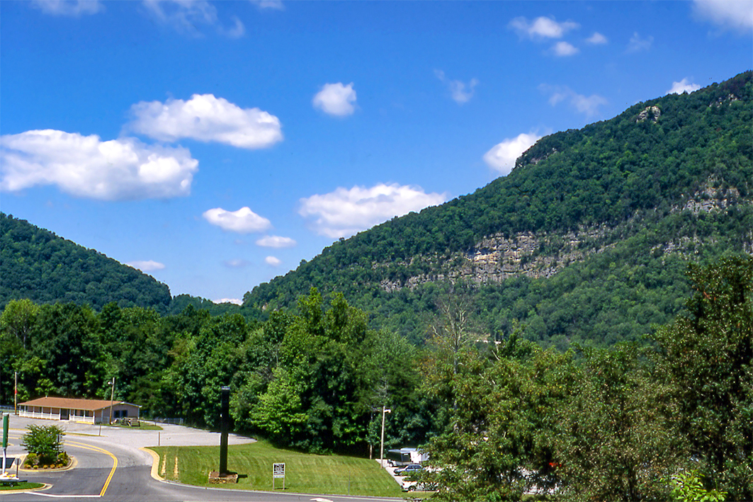
A wind gap is: “A shallow notch in the crest or the upper part of a mountain ridge. Usually, it is at a higher level than a water gap.”14 To qualify as a wind gap, the notch has to be an erosional notch and not caused by faulting or some other mechanism. In other words, the top of the entire ridge, at one time, was level and at about the same altitude, until a notch was eroded into the ridge across its top. Figure 5 shows the famous Cumberland wind gap between Virginia and Kentucky, USA. The early pioneers frequently used this gap when traveling west through the Appalachian Mountains. A wind gap is considered an ancient water gap, but which was later left high and dry.
Major mysteries of uniformitarian geology

Despite the above three main ideas and several minor ideas, the origin of water and wind gaps, assuming present processes, remains a mystery. Thomas Oberlander, who has extensively researched water gaps, opines:
“Large streams transverse to deformational structures [i.e. streams flowing through water gaps] are conspicuous geomorphic elements in orogens [mountain ranges] of all ages. Each such stream and each breached structure presents a geomorphic problem. However, the apparent absence of empirical evidence for the origin of such drainage generally limits comment upon it [emphasis added].”15
Channelized Flood runoff easily carved water and wind gaps
Water and wind gaps were formed as the global floodwaters drained off the uplifting continents across the mountains.16 Figure 6 shows water flowing perpendicular to a transverse ridge, forming shallow notches on the ridge. These notches continue to erode downward as the water accelerates through the notch as the water level drops. After the Flood water is completely drained, rivers take advantage of the newly-formed channel. Wind gaps were formed in the same way but not cut as deeply, and are thus at too high an elevation for water to flow through them now.
More examples of water and wind gaps are those carved by the Lake Missoula Flood, a few hundred years after Noah’s Flood. This Ice Age Flood, now known to have carved the spectacular ‘Channeled Scablands’ of the northwestern USA out of solid rock, was probably the second largest flood in Earth history. It took place at the peak of the Ice Age. Despite overwhelming geological evidence for it, it required decades of struggle before eventually becoming accepted as a reality, so strong was the effect of the prejudice in favour of ‘slow and gradual’ mechanisms in geology. The Lake Missoula Flood is known to have carved numerous water and wind gaps through ridges.17,18 The evidence it left behind thus shows clearly how monstrous floods easily carve water and wind gaps.
References and notes
- Oard, M.J., Do rivers eroded through mountains? Water gaps are strong evidence for the Genesis Flood, Creation 29(3):18–23, 2007; creation.com/watergaps. Return to text.
- Oard, M.J., Flood by Design: Receding Water Shapes the Earth’s Surface, Master Books, Green Forest, AR, 2008. Return to text.
- Oard, M.J., (ebook), Earth’s Surface Shaped by Genesis Flood Runoff, 2013; Return to text.
- Neuendorf, K.K.E., Mehl, Jr., J.P., and Jackson, J.A., Glossary of Geology, Fifth Edition, American Geological Institute, Alexandria, VA, p. 715, 2005. Return to text.
- Neuendorf et al., ref. 4, p. 27. Return to text.
- Neuendorf et al., ref. 4, p. 645. Return to text.
- Vallier, T., Islands & Rapids: A Geological Story of Hells Canyon, Confluence Press, Lewiston, ID, 1998. Return to text.
- Bradley, W.H., Geomorphology of the North Flank of the Uinta Mountains, U. S. Geological Survey Professional Paper 185—I, Washington, D.C., 1936. Return to text.
- Powell, J.L., Grand Canyon: Solving Earth’s Grandest Puzzle, PI Press, New York, NY, p. 8, 2005. Return to text.
- Powell, ref. 9, p. 152. This would be very late in Noah’s Flood within the biblical timeframe. Return to text.
- Oard, M.J. A Grand Origin for Grand Canyon, Creation Research Society, Chino Valley, AZ, 2014. Return to text.
- Lavé, J. and Avouac, J.P., Fluvial incision and tectonic uplift across the Himalayas of central Nepal, Journal of Geophysical Research 106(B11):26,561–26,591, 2001. Return to text.
- Oberlander, T.M., Origin of drainage transverse to structures in orogens; in: Morisawa, M. and Hack, J.T. (Eds), Tectonic Geomorphology, Allen and Unwin, Boston, MA, pp. 155–182, 1985. Return to text.
- Neuendorf et al., ref. 4, p. 723. Return to text.
- Oberlander, ref. 13, p. 155. Return to text.
- Walker, T., A biblical geologic model; in: Walsh, R.E. (Ed.), Proceedings of the Third International Conference on Creationism, technical symposium sessions, Creation Science Fellowship, Pittsburgh, PA, pp. 581–592, 1994; biblicalgeology.net. Return to text.
- Oard, M.J., The Missoula Flood Controversy and the Genesis Flood, Creation Research Society Books, Chino Valley, AZ, 2004. Return to text.
- Oard, M.J., The Great Missoula Flood: Modern Day Evidence for the Worldwide Flood, Awesome Science Media, Canby, OR, 2014. Return to text.

Readers’ comments
Comments are automatically closed 14 days after publication.